Request Add-On
MOST POPULAR FLEET MANAGEMENT ADD-ONS

GoAnalytics
GoAnalytics is an add-in tool designed to simplify the viewing and reporting on large amounts of driver data. Telematics, Video and engine data are all available and easily actionable from interactive dashboards.
Providing fleet managers with high-level views of your company’s performance, our digital scorecard provides customizable risk scores that are calculated by the driver. This enables users to quickly drill down and identify the riskiest drivers.
The Engine Faults and Preventative Maintenance section instantly highlights vehicles that require immediate attention and should be removed from service before they fail in the field.
GoAnalytics amplifies your Geotab experience by merging diverse data sources, delivering instant actionable insights to fleet operations. It blends Geotab's telematics data with other vital fleet information, empowering efficient decision-making for enhanced performance and cost savings.
Coaching is a key factor in fleet safety. Our system allows managers to coach and document in driver files.
Features And Benefits
Features
- Interactive Dashboard
- Simplified Video Management
- Digital Scorecards
- Combined Telematics and Video data
- Customizable Reporting views
- Drill Down ability for fleets.
- Built-in Coaching
- Manager Engagement tracking
- Dismiss & hide invalid exceptions
- Ability to pull in 3rd party data via API
By: GoGPS


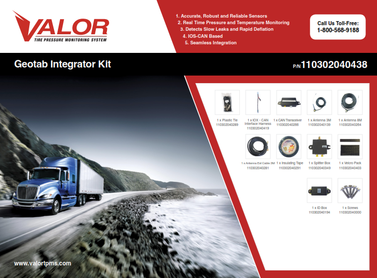
Tire Pressure and Temperature Monitoring
Valor TPMS
By: Valor
Solution Type: Hardware Accessories & Add-Ons, MyGeotab Add-ins, General Software Solutions
Category: In-Vehicle Sensors & Electronics
Region: Global
Language: English, French, Spanish
Device Requirements: GO6, GO7, IOX-CAN required
Minimum MyGeotab Plan: ProPlus
Current Status: Released
Description
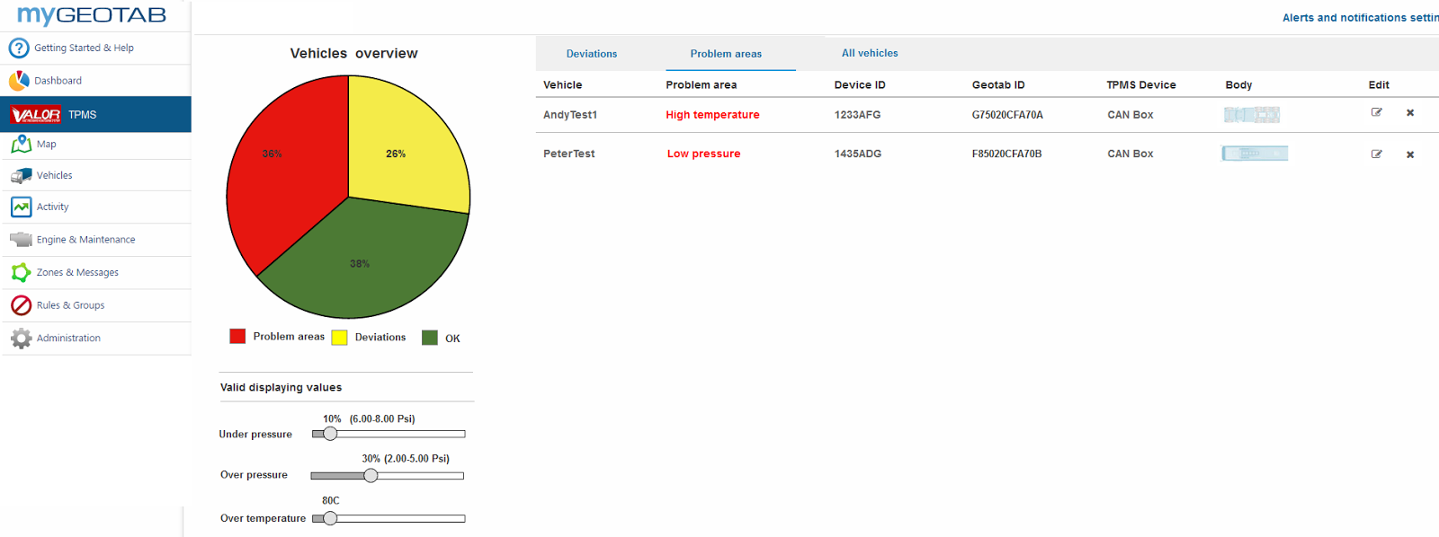
The system monitors tire pressure and tire temperature in real time and transmits data through your GO device to MyGeotab.
Valor also provides multiple Geotab Add-ins that provide the following functionality:
Main Page
- Identifies vehicles that are outside of user defined zones – red or yellow
Drill down to look at a vehicle or multiple vehicles separated by yellow, red or green zones.
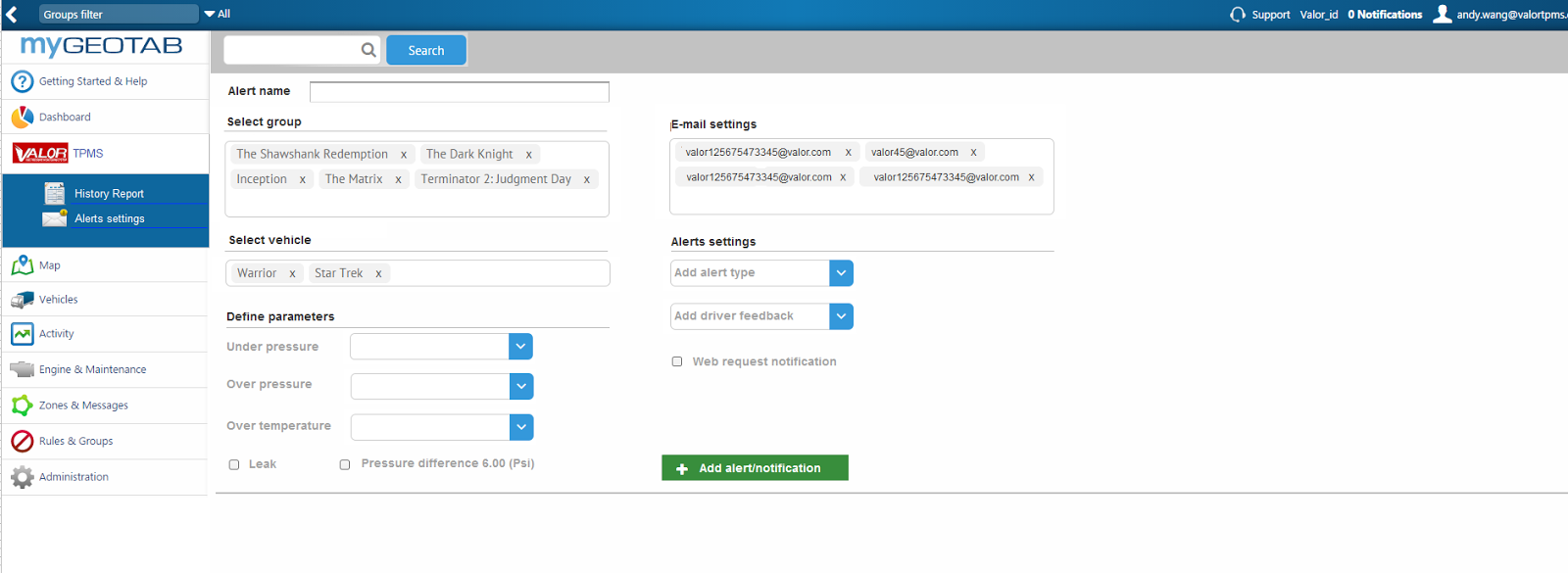
Alerts page
- Identifies the issue and allows for the drill down of the detail on a vehicle basis,
- Select a time period and look at the history
- Configure custom parameters in order to focus on trends
Alerts and settings page
- Allows the user to define the value for the alerts and the recipients where the alert is sent.
- Rules are pre-programed with the value being user settable
- Configure units of measure – PSI, BAR, Fahrenheit, etc.
- Configure Report types and distribution lists
Who Should Use This
Commercial truck fleets, Bus operators, Service vehicles (EMS, FIRE, Ambulance) – any fleets that wish to monitor their tire pressure and be alerted to tire issues
Features & Benefits
- Real-time monitoring of pressure and temperature, every 4 seconds
- Immediate SMS or email alerts for over- and under pressure changes
- Wirelessly monitor up to up to 6 axles and 24 tires per vehicle
- System has automatic drop and hook for trailers
- can link up to 3 trailers to one tractor
- Real-time monitoring removes the need for manual inspection
- “Out of bounds” warnings alert you to potential issues
- Real time monitoring of both pressure and temperature allows you to deliver safely and with confidence

Reefer Temperature Monitoring
Valor TempTrac
By: Valor
Solution Type: Hardware Accessories & Add-Ons, MyGeotab Add-ins
Category: In-Vehicle Sensors & Electronics
Region: Global
Language: English, French, Spanish
Device Requirements: GO6 or GO7; IOX-CAN required
Minimum MyGeotab Plan: ProPlus
Current Status: Released
Description
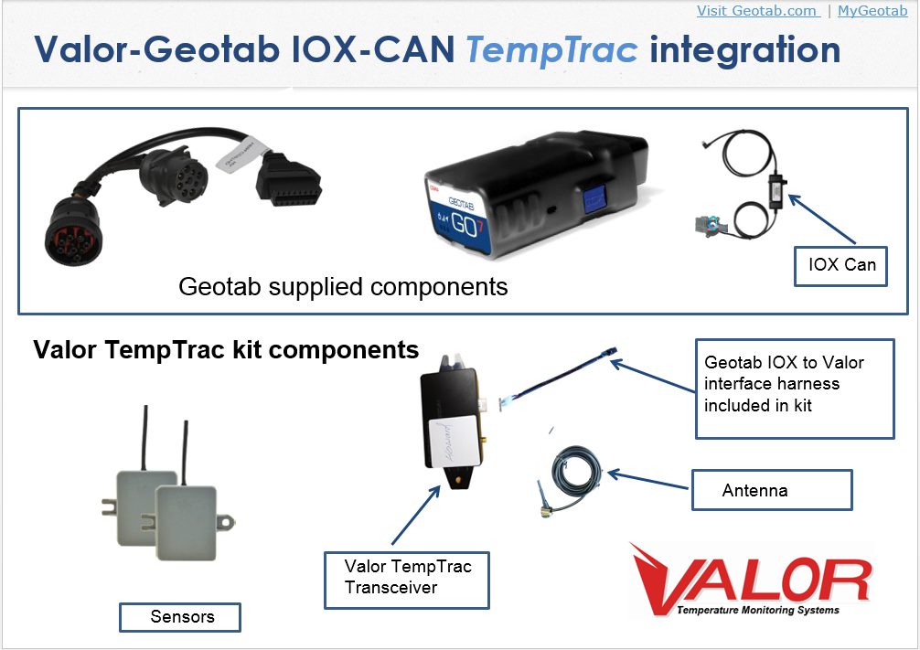
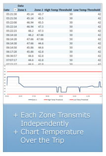
Our patented solution monitors up to four temperature zones simultaneously and transmits temperature readings through your GO device to MyGeotab in real time. Two sensors are included in the kit with the ability to purchase additional sensors separately as required.
Valor also provides multiple Geotab Add-ins that provide the following functionality:
Main Page
- Identifies vehicles that are outside of user defined zones – red or yellow
- Drill down to look at a vehicle or multiple vehicles separated by yellow, red or green zones.
Alerts page
- Identifies the issue and allows for the drill down of the detail on a vehicle basis,
- Select a time period and look at the history
- Configure custom parameters in order to focus on trends
Alerts and settings page
- Allows the user to define the value for the alerts and the recipients where the alert is sent.
- Rules are pre-programed with the value being user settable
- Configure units of measure – Celsius, Fahrenheit, etc.
- Configure Report types and distribution lists
Who Should Use This
Companies that ship fresh produce, frozen goods, or high-value assets such as pharmaceuticals via refrigerated transport.
Features & Benefits
- Real-time monitoring of temperature, samples every four seconds, transmits every ten seconds, or 1 degree temperature change.
- Immediate SMS or email alerts for over- and under-temperature changes
- Track temperatures through the life of a shipment and trend temperatures over time
- Wirelessly monitor up to 4 Zones
- Real-time monitoring removes the need for manual temperature inspection
- “Out of bounds” temperature warnings alert you to potential issues
- Understanding temperature throughout your chain of custody allows you to deliver safely and with confidence

Interactive Dashboards
Analytics, Scorecards, Real-time Workflow
By: Maps BI Inc.
Solution Type: Hardware Accessories & Add-Ons, MyGeotab Add-ins
Category: In-Vehicle Sensors & Electronics
Region: Global
Language: English, French, Spanish
Device Requirements: GO6 or GO7; IOX-CAN required
Minimum MyGeotab Plan: ProPlus
Current Status: Released
Description
Maps BI connects directly to Geotab’s GO devices to give you instant and automated access to beautiful, easy-to-understand interactive dashboards. You can either create your own dashboard from scratch or start from one of our out-of-the-box dashboards. What’s more, our platform allows you to easily tie together Geotab data with other systems including systems built for work orders, human capital management, and more. Don’t be fooled by our name, our data visualizations and dashboards don’t have to be on a map!
With Maps BI, you’ve got a few options:
Choose from one of our basic dashboards that can be applied across industries.
Select from one of our industry-specific dashboards to meet your organizationès specific needs.
Or, we’ll work with you to pull together and customize a unique data visualization soluton for you via a series of interactive dashboards that you can easily access on an on-going basis.
Some of our existing dashboard solutions include:
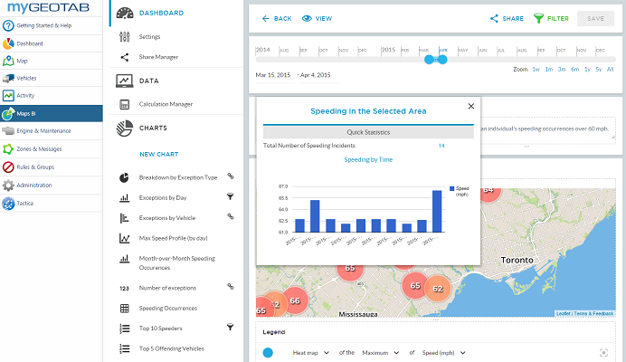
- Interactive Speeding Dashboard
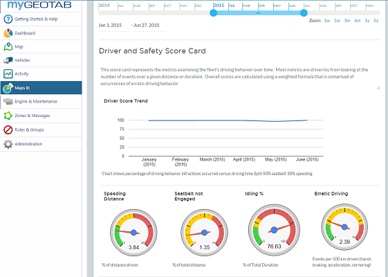
A visual depiction on a map that shows where your organization is speeding most. It shows you month-over-month/week-by-week trends, and allows you to filter for specific vehicles and/or departments. - Driver and Safety Scorecard
Perfect Dashboard for managers and C-Level executives to track corporate safety and performance on a month-over month basis. Easily define what is representative of a risk score for your organization (i.e. 50% Speeding, 30% Erratic Driving, 20% Seatbelt). - Delivery Status (Route Overlay)
Real-time operational dashboard to track planned routes against actual routes. ETAs and ETDs are automatically calculated and you visually see how all of your routes for the day are performing. Track back to history if needed, and have automated daily route imports from routing systems. - Temperature Tracking + Delivery Status
Track temperatures in trailers in addition to delivery status to provide necessary compliance for system audits and customer complaints (i.e. for food or pharmaceutical delivery). - Speeding Bands Dashboard
Look at your speeding occurrences by speeding bands. Find top offenders and then zoom into a map that shows where and when these offences are taking place. - Interactive Idling Dashboard
This dashboard shows idling incidents and severity within an organization on an interactive map. It shows month-over-month trends, top idlers by time and location, and allows you to drill into specific vehicles and departments. - Fleet Utilization Dashboard
Easily see how frequently your fleet is used on a month-over-month and week-by-week basis. This gives you real-time and historic insight into underutilized assets in order to better deploy and utilize resources. - Utilities: PTO Hours + Boom out of Rest
Perfect for utilities to track Power Take Off (PTO) hours and boom-out-of-rest hours against their idling time. These metrics allow the utility company to see which vehicles are idling inefficiently and also to prove PTO idling hours for government tax credits. - Geotab + Other Telematics: All-in-One
Looking to merge multiple telematics datasets into one system? No problem. This dashboard overlays sample Skybitz location data with Geotab data so that all assets are tracked in one spot. - Customers and Sales
This dashboard has less to do with telematics, but can be used to import sales data from a CRM like Saleforce.com (or even just an Excel spreadsheet). Sales can then be monitored on their own or overlaid against how much time is being spent with the customer (via telematics feed).
Who Should Use This
Maps BI is a versatile package with visualizations that make sense for everyone from C-Level executives straight through to fleet managers and drivers.
Features & Benefits
- Features:
- Create your own interactive dashboards using an easy drag-and-drop interface
- Setup custom KPIs and calculations from your data
- Access everything via the web – no need to download third party applications or bring anything into Excel
- Link multiple dashboards together to tell a story of your data
- Share reports by web link, PDF, automated email scheduling, or even embedding a dashboard into your customer’s website
- Drill-down and interactively filter your data by multiple dimensions: date/time, vehicle, zone, driver, exception type, and more
- Automatically integrated user groups and permissions with myGeotab
- Overlay multiple layers on top of your telematics data, including work orders, route planning, and more
- Visualize your geographic data using heat maps, markers, regional territory maps, gauges, top 10 lists, tables, customizable pop-ups, line charts, bar charts, pie charts, and more
Benefits:
- Use our platform not only for retrospective analysis, but for real-time operational needs involving work order allocation, temperature tracking, winter operations, and more
- Spend more time acting on insights instead of trying to understand and access your data
- Reduce costs and uncover operational inefficiencies and patterns
- Have your telematics data, work order data, dispatch data, and other line-of-business systems funnel into a single platform for instant visualization
- Save time with fast and interactive insight into your telematics data
- Reduce costs by empowering your team to create their own reports on-the-fly via our easy-to-use web interface

Grace Mobile Lone Worker GPS Safety Monitoring
Grace SC500 GeoPointsᶲGPS® -Worker Worn GPS
By: Grace Industries Inc.
Solution Type: Hardware Accessories & Add-ons
Category: Remote Workers, Safety
Region: Global
Language: English
Device Requirements: GO6/GO7 + IOX-RS232-M
Minimum MyGeotab Plan: ProPlus
Current Status: Released
Description
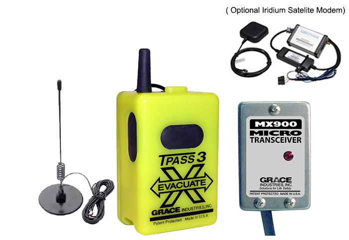
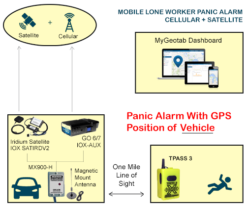
High Performance Wireless Personal Alert Safety System capable of send panic alarms with the worker’s GPS position up to 1 mile from the worker to the vehicle. The SC500 GeoPointsᶲGPS® is a worn by the worker and communicates with the vehicle mounted MX900-H transceiver. GPS position of the worker (requires Add-In by Zenduit). The Zenduit Add-In provides email alarm notification with geocoded address and link to map worker’s location. The SC500 includes an out of range alert and display when disconnected from Geotab or out-of-range of the vehicle. The SC500 GeoPointsᶲGPS® is rechargeable, UL/CSA intrinsically Safe and rugged IP67. 24 hours of operation with a 6-8 hour recharge time. Kit includes SC500 GeoPointsᶲGPS®, MX900-H, 120VAC Charger and External Magnetic Mount Antenna and is integrated with a reseller supplied GO6 or GO7 and the IOX-RS232-M cable
Who Should Use This
Limitless applications, used in any industry to satisfy an employer’s responsibility in compliance with Lone Worker regulation; examples include, utility workers, HVAC, remote service repair.
Features & Benefits
SC500 GeoPointsᶲGPS®
- LCD Display- visual indication of Out-of-Range
- Extreme Temperature- tested and accepted in Northern Canada and US desert regions
- GPS Receiver- 3 meter accuracy locates a worker up to 1 mile (line of sight) from the vehicle
- IP67- rated for rugged dust/water/shock/vibration
- Intrinsically Safe- for hazardous environments
- 120VAC Charger- ships standard with 120VAC charger- available with International Charger12 VDC- order as an option- 12 VDC vehicular charger.
MX900-H Transceiver Gateway
- Compact Design- mount on dash or truck’s rear window
- Antenna- ships with screw on type antenna for a choice of inside vehicle + external vehicle magnetic mount antenna
- 12-24 VDC Operation- Internally fused- requires direct connection to continuous “ignition-less” vehicle power source.

Geotab Drive
Geotab’s Driver Application
By: Geotab Inc.
Solution Type: Mobile Apps
Category: Compliance, Dispatch & Workflow, Driver Tools
Region: Global
Language: English
Device Requirements: GO6 or GO7; IOX-USB; and Android or iOS compatible device
Mobile Version: Android 4.4, or iOS 6.0
Minimum MyGeotab Plan: Pro
Current Status: Released
Description
Geotab Drive is a smart Driver app for Android and iOS phones and tablets. Syncing data between the Geotab GO device and the tablet, it works in conjunction with MyGeotab software to provide Driver Vehicle Inspection Reporting and an FMCSA compliant HOS solution.
Geotab Drive provides several useful services to drivers in your fleet:
- DVIR (Driver Vehicle Inspection Reporting)
- HOS (Hours of Service)
- Driver Identification
Who Should Use This
Fleets looking for DVIR, HOS and/or Driver identification solutions.
Features & Benefits
Geotab Drive
- Supports Off-The-Shelf Android and iOS devices
- Built on HTML5
- Open and flexible platform for adding and removing applications
- Over the Air software and firmware updates
Hours of Service (HOS) with Geotab Drive
Ensuring driver safety and achieving the highest compliance standards are high priorities for drivers and managers. HOS regulations help keep fatigued drivers off public roadways by placing limits on when and how long a driver can be on the road. This reduces crashes, injuries, and fatalities related to operating commercial motor vehicles. Failure to comply can result in heavy fines, loss of license, or a fleet being stripped of its operating authority.
Benefits
- US Federal FMCSA 395.15 compliant
- Track regulated driver's time spent in each duty status
- Automatic duty status changes - On Duty to Driving; Driving to On Duty
- Violation Alerts
- Alerts for Drivers not logged in
- Co-Driver support
- Big Day support
- Adverse Weather Conditions
- Platform for future rule support
- Platform for Dispatch application support
- Visibility in MyGeotab of Driver Logs, Violations, and Hours Remaining
Driver Vehicle Inspection Reporting (DVIR) with Geotab Drive
- Complete end to end Inspection workflow
- Drivers select defects, add comments, review previous inspections, and approves
- Inspections show defects, who created the report, and when

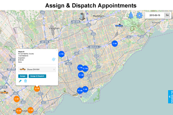
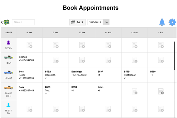
Appointment Dispatching
By: PaperDoDo Inc
Solution Type: MyGeotab Add-Ins, Mobile Apps
Category: Dispatch & Workflow, Driver Tools, Planning / Scheduling
Region: North America
Language: English
Device Requirements: Any GO device, any Smartphone
Minimum MyGeotab Plan: Base
Current Status: Released
Description
PaperDoDo is a suite of mobile workforce management add-ins designed to make mobile service businesses easier to operate and more profitable.
PaperDoDo Scheduler makes:
- Scheduling, dispatching, and communicating with drivers more efficient.
- Dispatchers can book appointments within Geotab and see a bird’s eye view of the entire fleet.
- Dispatchers assign appointments to closest drivers
- Driver automatically receives updated appointment schedule on smart phone
Who Should Use This
Companies looking to make the appointment scheduling and dispatching more efficient.
Some industries include:
- Plumbing
- Electrical
- Heating & Air Conditioning
- Courier
- Locksmith
- Garage doors
- Taxi
- Pest Control
- And more
Features & Benefits
- Appointment scheduling
- Dispatch drivers by: app, email, or text
- Live text chat between dispatcher and drivers
- Drag and drop interface
- Estimate time of arrival for customer
- Reduce labor and gas costs
- Improve employee productivity
- Improves customer service

Remote Diagnostics
OnCommand Connection (OCC)
By: Navistar International Corporation
Solution Type: General Software Solutions, Mobile Apps
Category: Vehicle Maintenance
Region: Global
Language: English
Cost: Free
Device Requirements: GO6 and GO7
Mobile Version: Android and iPhone
Minimum MyGeotab Plan: Pro
Current Status: Released
Description
GreenMile provides a cloud-based vehicle performance management and dispatching platform for companies that need to better measure the performance of their mobile resources, reduce their transportation costs and increase customer satisfaction. GreenMile combines Geotab’s telematics information with planned routes from many of the top routing software providers to deliver actionable information throughout an organization. The result is a Geotab Add-In tool that provides companies with vehicle telematics & GPS data, route execution, real-time actual vs plan (AvP) data, and vehicle tracking all from within the same application. Additional benefits include the ability to seamlessly update existing route planning software with improved data from the field.
Who Should Use This
Delivery and service organizations interested in capturing the actual vs. plan KPI’s of their mobile resources in order to measure and improve efficiency in the field.
Features & Benefits
- Integrated with the Geotab solution as well as multiple routing systems
- Monitor telematics data within the dispatching application
- Real-time actual vs plan (AvP) reporting
- Visibility of planned routes, stops, and orders
- Update real-time data back into current routing software
- Mobility apps allow tracking of sales & merchandisers
- GPS data layered over top of planned route paths
- Reduced transportation costs
- More efficient route planning and tracking
- Ability to answer “where’s my delivery” questions
- Real time ETA’s of deliveries with auto notifications
- Easily identify operational inefficiencies & patterns
- Proactive alerts


Improve Route Planning and Execution
By: GreenMile
Solution Type: Mobile Apps, General Software Solutions, Custom Reports
Category: BI & Data Analytics, Dispatch & Workflow, Driver Feedback, Driver Tools, In-Vehicle Sensors & Electronics, Mapping & Navigation, Planning / Scheduling, Route Optimization, Safety, Time Management
Region: Global
Language: English, Spanish, Portuguese, French, Hebrew, Japanese, Czech, Italian
Device Requirements: All GO devices supported.
Minimum MyGeotab Plan: Base
Current Status: Released
Description
GreenMile provides a cloud-based vehicle performance management and dispatching platform for companies that need to better measure the performance of their mobile resources, reduce their transportation costs and increase customer satisfaction. GreenMile combines Geotab’s telematics information with planned routes from many of the top routing software providers to deliver actionable information throughout an organization. The result is a Geotab Add-In tool that provides companies with vehicle telematics & GPS data, route execution, real-time actual vs plan (AvP) data, and vehicle tracking all from within the same application. Additional benefits include the ability to seamlessly update existing route planning software with improved data from the field.
Who Should Use This
Delivery and service organizations interested in capturing the actual vs. plan KPI’s of their mobile resources in order to measure and improve efficiency in the field.
Features & Benefits
- Integrated with the Geotab solution as well as multiple routing systems
- Monitor telematics data within the dispatching application
- Real-time actual vs plan (AvP) reporting
- Visibility of planned routes, stops, and orders
- Update real-time data back into current routing software
- Mobility apps allow tracking of sales & merchandisers
- GPS data layered over top of planned route paths
- Reduced transportation costs
- More efficient route planning and tracking
- Ability to answer “where’s my delivery” questions
- Real time ETA’s of deliveries with auto notifications
- Easily identify operational inefficiencies & patterns
- Proactive alerts

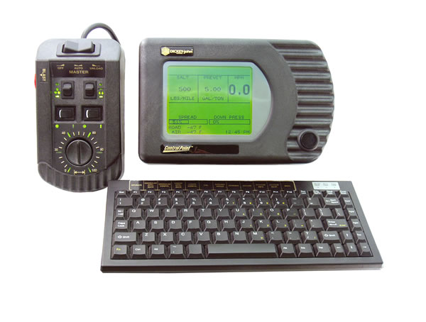
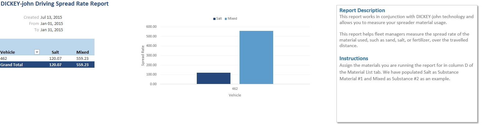
DICKEY-john Control Point Integration
IOX-DJ
By: Geotab Inc.
Solution Type: Hardware Accessories & Add-Ons
Category: In-Vehicle Sensors & Electronics
Region: Global
Device Requirements: GO6, GO7
Minimum MyGeotab Plan: ProPlus
Current Status: Released
Description
IOX (Input / Output Expanders) plug directly into the GO device and are used to extend the GO device to peripherals in your vehicle. Leveraging the CAN networks that run on the GO device, IOXs can be daisy-chained together meaning multiple peripherals can be added to the GO device. This adds flexibility to your implementation, even after installation, and means the Geotab solution can grow as your fleet needs grow.
The IOX-DJ connects to the DICKEY-john Control Point Control System to provide distances, time, and amount of granular and liquid materials being spread during winter storm events. The data is captured through the IOX and transmitted up to MyGeotab where exceptions can be created and reports generated
Who Should Use This
DICKEY-john has customers ranging from individual farmers to original equipment manufacturers (OEMs). Amongst other markets, DICKEY-john provides systems for snow equipment vehicles which Geotab has focused on.
Features & Benefits
- View on a map which roads have been salted or sanded or had other material applied
- View areas on a map where blasting occurred
- Track distance, quantity, and time spent sanding, salting, blasting, or applying other materials
- Compare application rates to ensure some drivers are not over or under applying material

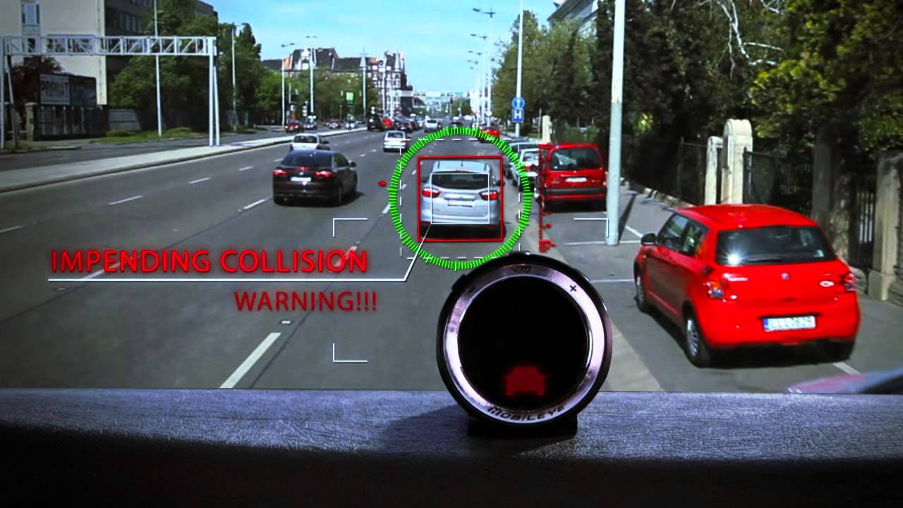
Advanced Collision Prevention
By: Mobileye
Solution Type: Hardware Accessories & Add-Ons
Category: Driver Feedback, Driver Training, Safety
Region: Global
Device Requirements: GO6 or GO7; IOX-CAN
Minimum MyGeotab Plan: ProPlus
Current Status: Released
Description
Mobileye is a collision avoidance system that reduces the number and severity of accidents in fleets and passenger vehicles, driver infractions, and in many cases provides a reduction in fuel and maintenance costs. It mounts to the inside of the windshield and is about the size of a toll pass tag. The system provides visual and audible alerts to the driver in case of imminent collisions.
Driver warnings are transmitted through the IOX-CAN to the GO7 and up to MyGeotab where Managers and Dispatchers can view the information in reports, create rules and exceptions, and apply driver policies.
Who Should Use This
Any fleet interested in equipping their drivers with a tool to warn them of impending collisions, unsafe lane changes, or following too close.
Features & Benefits
Supports all vehicle types – light duty, medium duty, and heavy duty vehicles
All driver alerts transmitted to MyGeotab for mapping, reporting, and driver score card purposes
Warnings and Alerts for drivers and managers for:
- Unintentional lane departures
- To keep safe distances from vehicles ahead
- Forward collision warnings
- Pedestrian and bicycle collision warnings
- Supports all vehicle types
- Lane departure alerts if there is an unintentional lane departure
- Provides alerts to help keep safe distances from vehicles ahead
- Forward collision warning
- Pedestrian and bicycle collision warning
- Speed limit indication to read speed signs and provide alerts
- Fewer collisions and close calls
- Increased driver reaction time
- Self-corrected driver habits and behavior
- Reduced insurance premiums and fines for non-compliance
- Improved CSA scores
- System typically pays for itself in 6 – 8 months

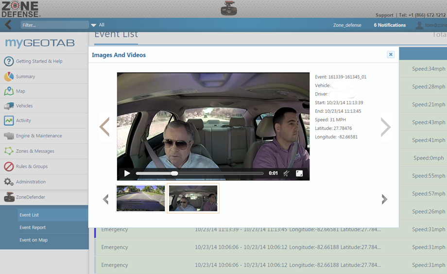
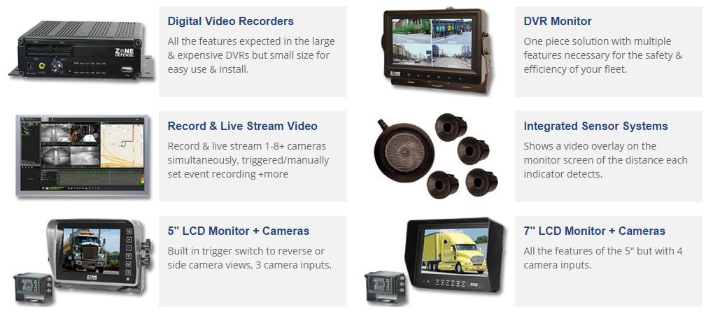
Driver's Camera
Images and Videos for Driver’s Coaching and Accident Recreation
By: Zone Defense
Solution Type: Hardware Accessories & Add-On, MyGeotab Add-ins
Category: Asset Management, Cameras, Driver Training, Safety, Solution Integration
Region: Global
Language: English
Device Requirements: GO6, GO7
Minimum MyGeotab Plan: Base
Current Status: Released
Description
Developed by Zone Defense, this plug-and-play high resolution camera with night vision offers both front and in-cab facing cameras. Not only will you have the telematics data in the event of a collision or coaching opportunity but photographic evidence as well. Automatic events include impact, speeding, sudden stops, and motion. Plus, it offers a bookmark button for manually triggered events.
Also developed by Zone Defense is a Geotab Add-in that brings videos right into MyGeotab. The Add-in allows users to view the video:
- By the vehicle
- As an Event Report
- On the map with Event colored breadcrumbs
Who Should Use This
Anyone who wants video and images in MyGeotab.
Features & Benefits
- Integrated GPS antenna, impact sensor, speaker, and microphone
- Automatically records events and pinpoints the location of the event
- Sort videos by event type or date
- Bookmark button and extension cord so events can be triggered manually
- Voice guide to inform the condition of the device
- Save video, audio, and pictures right to your desktop with time, date, position, and speed from the internal memory
- Record coaching opportunities such as driver’s fatigue, smoking, or cell phone use
- Protect yourself in the event of a collision with photos, video, and a panorama thumbnail view for easy playback of the entire event at once
- Lane departure overlay for liability protection
- Simple plug-and-play installation with power from the vehicle’s battery
- Optional automatic overwrite for normal driving saving only the event videos for longer work periods
- Possible reduction in insurance rates due to having an anti-theft deterrent in the vehicle

Active Prevention of Distracted Driving
By: Dock-n-Lock LLC
Solution Type: Hardware Accessories & Add-Ons, MyGeotab Add-Ins
Category: Compliance, Driver Feedback, Driver Tools, Safety, Solution Integration
Region: Global
Language: English
Device Requirements: GO6 or GO7; IOX-RS232″
Mobile Version: Coming soon
Minimum MyGeotab Plan: Pro
Current Status: Beta
Description
A Dock-n-Lock® Safe Driving System consists of a phone box installed in the vehicle, tamper proof NFC smart tags, and a web application to manage drivers, permissions, and reporting. A non-invasive NFC tag programmed to access the vehicle gets placed inconspicuously on the driver’s phone. The tagged phone must be in the phone box to start the vehicle. The Dock-n-Lock® system safeguards and monitors the phone while the vehicle is on, providing companies an end to end solution to enforce compliance of their mobile usage policy for drivers, and to maximize safety by keeping the phone out of reach, and sight.
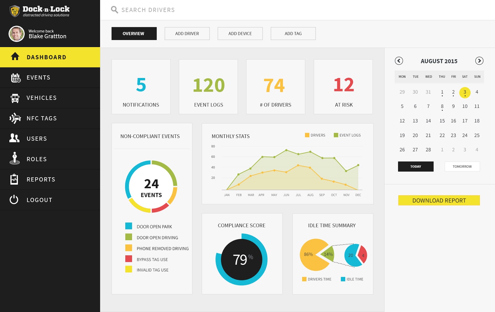
The Dock-n-Lock system also provides a Geotab Add-in which provides users a summary of a driver's compliance record. The Add-in provides the Manager or Supervisor a "Driver Dashboard" showing driving time in compliance represented as a percentage of overall driving time. Also, a list of any driver violations such as DNL box open (drive and park); invalid tag used; system bypass tag used; and phone removed. A fleet wide report showing any tags set to expire and overall compliance statistics will be completed later this summer.
Who Should Use This
If your company is looking to improve safety, mitigate risk, and increase driver compliance with your mobile usage policy, an integrated Dock-n-Lock Safe Driving System is the most effective and compatible system on the market. Now you can set clear rules for drivers, and accurately monitor and report compliance.
Features & Benefits
- Safeguard phone out of sight and reach
- Configurable to meet safety, compliance, and operational needs
- Compatible with all phone makes and types
- Manage driver access to vehicles
- Active anti-theft
- Supports multiple drivers per vehicle
- No privacy invasive software needed
- Bluetooth® hands free compatible
- Accurate, does not affect the passengers
- Charging accessible
- Safeguards to prevent tampering
IOX SERIES FLEET MANAGEMENT ADD-ONS
Live In Vehicle Verbal Feedback
IOX-GOTALK
By: Geotab Inc.
Solution Type: Hardware Accessories & Add-Ons
Category: Compliance, Driver Feedback, Driver Training, Safety
Region: Global
Device Requirements: GO6, GO7
Minimum MyGeotab Plan: Pro
Current Status: Released
Description
IOX - Input / Output Expanders - plug directly into the GO device and are used to extend the GO device to peripherals in your vehicle. Leveraging the CAN networks that run on the GO device, IOXs can be daisy-chained together meaning multiple peripherals can be added to the GO device. This adds flexibility to your implementation, even after installation, and means the Geotab solution can grow as your fleet needs grow.
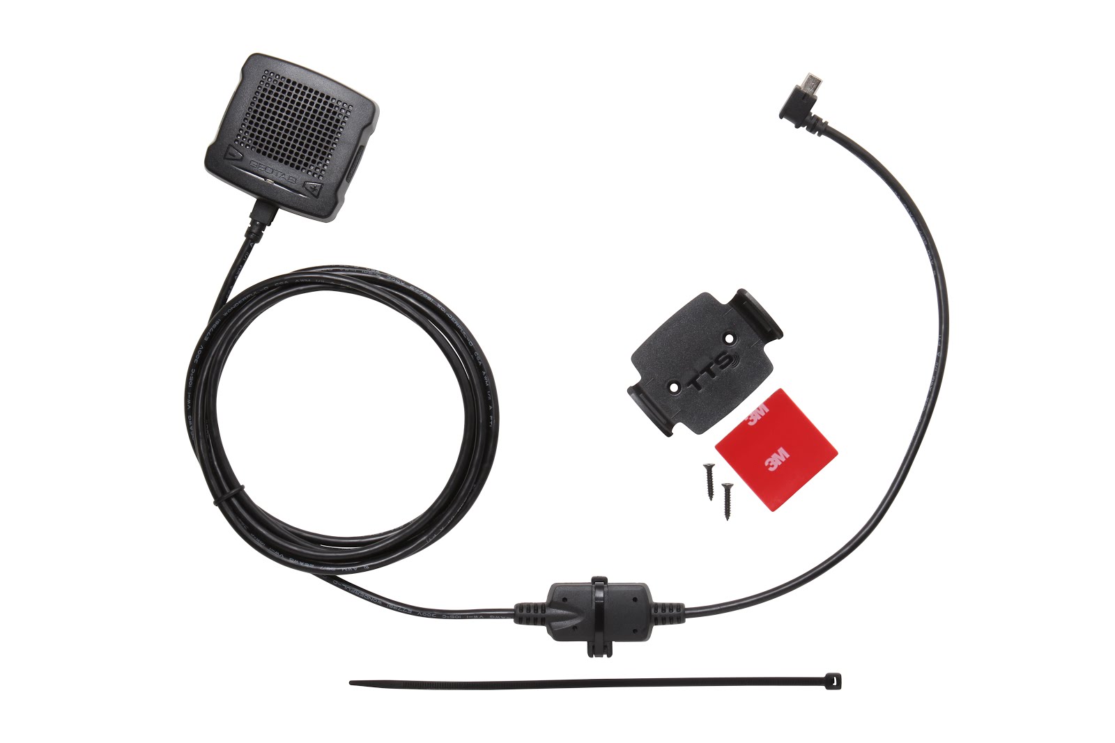
To further establish Geotab’s commitment to Safety and Driver Feedback, the GO TALK provides real time spoken alerts to Drivers. Using text-to-speech, the GO TALK provides real-time feedback to drivers based on predefined rules. Any rules that the GO device uses today to alert the driver with beeps can be used with the GO TALK.
With the addition of Active Tracking, drivers will get near-real-time feedback (generally within 5-10 seconds) when in good coverage from MyGeotab-based rules as well.
Custom text for MyGeotab-based rules can be added to provide specific messaging to help the driver understand what they may have done wrong, or right. Benefits to customized messages include the ability to create a message specific to the violation being encountered, as well as the ability to create the kinds of positive messages your drivers will respond to. Include tokens such as driver name, address of the violation, and zone name to provide the driver with a detailed account as to where and when the violation occurred.
Who Should Use This
GO TALK is perfect for any fleet that wants to provide more information to its drivers about their driving habits. It will allow fleets to improve driving habits over time while empowering their drivers with helpful, real time feedback. It will also help improve driver safety, by teaching them good habits over time.
Features & Benefits
- Real time spoken driver feedback
- Customize text to speech messages for drivers
- Provide drivers with steps to improve driving habits
- Improve fleet safety
- Plug-and-play, quick installation

Measuring External Vehicle Inputs
IOX-AUX
By: Geotab Inc.
Solution Type: Hardware Accessories & Add-Ons
Category: In-Vehicle Sensors & Electronics
Region: Global
Device Requirements: GO6, GO7
Minimum MyGeotab Plan: Pro
Current Status: Released
Description
IOX (Input / Output Expanders) plug directly into the GO device and are used to extend the GO device to peripherals in your vehicle. Leveraging the CAN networks that run on the GO device, IOXs can be daisy-chained together meaning multiple peripherals can be added to the GO device. This adds flexibility to your implementation, even after installation, and means the Geotab solution can grow as your fleet needs grow.
The IOX-AUX supports up to 4 digital inputs each. These digital inputs can range from school bus warning lights, to doors opening and closing, to panic buttons for drivers to whatever sensor or input you need to track.
All the data captured by IOX-AUX are transferred to MyGeotab and accessible by the user to create rules and reports based on the readings.
Who Should Use This
The IOX-AUX is a great asset for companies looking to measure specific vehicle settings or external systems that are not already obtained by the GO device. This is ideal for customers that operate with specialized vehicles or for customers that operate in remote regions so they can improve driver safety.
Features & Benefits
- Support for up to 4 digital inputs per IOX-AUX. Two IOX-AUXs can be daisy chained together
- Intelligently self learns input signals
- Adds further functionality to the Geotab GO device

Increase Volume of Driver Feedback
IOX-BUZZ
By: Geotab Inc.
Solution Type: Hardware Accessories & Add-Ons
Category: Compliance, Driver Feedback, Driver Training, Safety
Region: Global
Device Requirements: GO6, GO7
Minimum MyGeotab Plan: Base
Current Status: Released
Description
IOX (Input / Output Expanders) plug directly into the GO device and are used to extend the GO device to peripherals in your vehicle. Leveraging the CAN networks that run on the GO device, IOXs can be daisy-chained together meaning multiple peripherals can be added to the GO device. This adds flexibility to your implementation, even after installation, and means the Geotab solution can grow as your fleet needs grow.
Geotab cares about Driver Feedback. The GO7 provides immediate feedback to the driver when over-revving, idling too long, speeding over a given threshold or by posted limits, “Dangerous Driving” (as defined by the customer), plus a myriad of server based rules customers can define for their fleet as a whole or individual drivers. Truly, a flexible and powerful system.
While the GO7 has a built in buzzer for driver feedback, the IOX-Buzz is an external buzzer which makes in-vehicle feedback louder for those really noisy environments.
In-vehicle feedback comes from both the GO device internal buzzer and the external buzzer to improve the sound quality of in-vehicle alerts, and to increase the likelihood that these alerts are received by the driver.
Who Should Use This
Each Geotab GO device comes with built-in audible buzzer alerts. This IOX-BUZZ can be used by anyone looking to increase the volume of the buzzer. This is ideal for those using large trucks, where sound amplification is required in order for the notification to be heard by the driver over the large vehicle engine noise.
Features & Benefits
- Driver Feedback
- Enhanced sound in loud noise environments
- Plug-and-play, quick installation

Integrating 3rd Party Devices and Data
IOX-CAN
By: Geotab Inc.
Solution Type: Hardware Accessories & Add-Ons
Category: In-Vehicle Sensors & Electronics, Solution Integration
Region: Global
Device Requirements: GO6, GO7
Minimum MyGeotab Plan: ProPlus
Current Status: Released
Description
IOX (Input / Output Expanders) plug directly into the GO device and are used to extend the GO device to peripherals in your vehicle. Leveraging the CAN networks that run on the GO device, IOXs can be daisy-chained together meaning multiple peripherals can be added to the GO device. This adds flexibility to your implementation, even after installation, and means the Geotab solution can grow as your fleet needs grow.
Geotab is always looking for way to provide more customization to our products and providing the customer with more and more data about their fleet. The IOX-CAN is a perfect example of our commitment to extending the functionality of the GO Device even more. With IOX-CAN, customers can incorporate a wide variety of third party products to report data to MyGeotab.
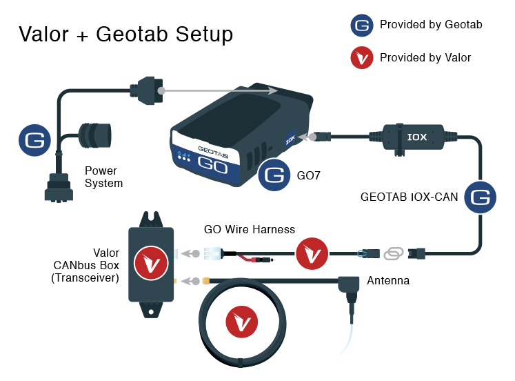
IOX-CAN is used for all Mobileye and Valor (TempTrac and TPMS) implementations. The IOX-CAN can also be used for partners or customers integrating third party products where they wish to transmit data from a device, through the Geotab GO device, and up to MyGeotab. This is accomplished utilizing Geotab’s Third Party protocol over a private CAN Bus connection via the IOX CAN.
The IOX-CAN is the fastest way for you to get information from third party devices and consolidate it in one place on MyGeotab. Once in MyGeotab, this data can be used to create rules and reports with even more metrics to measure your fleet.
Who Should Use This
Required for implementations of Mobileye products and all Valor products including TempTrac and TPMS.
Also useful for companies that require data from in-vehicle third party devices. Leverage the IOX-CAN for easy access to the information reported by the third party device in addition to the data from the GO Device. It can be used by anyone looking for third party device integration and is quick to set up and get running.
Features & Benefits
- Driver distraction monitoring through Mobileye
- Reefer Temperature monitoring (TempTrac) and Tire Pressure monitoring (TPMS) through Valor
- Provides a connection to Third Party devices to allow for transmission of data to MyGeotab

Driver ID with NFC technology
IOX-NFCREADER
By: Geotab Inc.
Solution Type: Hardware Accessories & Add-Ons
Category: Compliance, Dispatch & Workflow, Driver Feedback, Time Management
Region: Global
Device Requirements: GO6, GO7
Minimum MyGeotab Plan: Pro
Current Status: Released
Description
IOX (Input / Output Expanders) plug directly into the GO device and are used to extend the GO device to peripherals in your vehicle. Leveraging the CAN networks that run on the GO device, IOXs can be daisy-chained together meaning multiple peripherals can be added to the GO device. This adds flexibility to your implementation, even after installation, and means the Geotab solution can grow as your fleet needs grow.
Geotab is all about offering our customers ease of use and technology that improves the way they operate. The IOX-GARMIN provides a method for customers who specifically use dispatchers to communicate with their drivers. As an Authorized GARMIN Partner, Geotab provides seamless integration with some devices on the GARMIN platform.
The GARMIN device is easily connected to the GO Device using the IOX-GARMIN. Different models exist for different markets and can also optionally include traffic information. Once connected, the driver can use the GARMIN as an interface for communication with the dispatcher. It can be used to send routes and “stops” data to the driver for faster communication, increasing the efficiency of the fleet. The GARMIN device can also be used to record electronic HOS (hours of service) logs and eliminates the need for paper records.
Who Should Use This
Fleets that rely on drivers and make multiple deliveries per trip will benefit the most from the integration of a GARMIN Device through IOX-GARMIN. It will help you best optimize a route for a driver and send it down to the GARMIN device remotely.
The IOX-GARMIN can also be used by fleets and companies that rely on having a basis of navigation for their drivers and also keep in communication with them by sending messages to the GARMIN device with instructions and directions.
Features & Benefits
- Two-way communication between drivers and dispatchers
- Dispatchers can send stops and routes directly to the vehicle
- Touchscreen communication for drivers
- Communications are verified and time-stamped
- All driver information is displayed on a map
- Garmin Hours of Service (HOS)
- Plug-and-play, quick installation

Connector to Garmin for HOS and Navigation
IOX-GARMIN
By: Geotab Inc.
Solution Type: Hardware Accessories & Add-Ons
Category: Compliance, Dispatch & Workflow, Driver Feedback, Driver Tools, Mapping & Navigation, Route Optimization
Region: Global
Language: English
Device Requirements: GO6, GO7
Minimum MyGeotab Plan: Pro
Current Status: Released
Description
IOX (Input / Output Expanders) plug directly into the GO device and are used to extend the GO device to peripherals in your vehicle. Leveraging the CAN networks that run on the GO device, IOXs can be daisy-chained together meaning multiple peripherals can be added to the GO device. This adds flexibility to your implementation, even after installation, and means the Geotab solution can grow as your fleet needs grow.
Geotab is all about offering our customers ease of use and technology that improves the way they operate. The IOX-GARMIN provides a method for customers who specifically use dispatchers to communicate with their drivers. As an Authorized GARMIN Partner, Geotab provides seamless integration with some devices on the GARMIN platform.
The GARMIN device is easily connected to the GO Device using the IOX-GARMIN. Different models exist for different markets and can also optionally include traffic information. Once connected, the driver can use the GARMIN as an interface for communication with the dispatcher. It can be used to send routes and “stops” data to the driver for faster communication, increasing the efficiency of the fleet. The GARMIN device can also be used to record electronic HOS (hours of service) logs and eliminates the need for paper records.
Who Should Use This
Fleets that rely on drivers and make multiple deliveries per trip will benefit the most from the integration of a GARMIN Device through IOX-GARMIN. It will help you best optimize a route for a driver and send it down to the GARMIN device remotely.
The IOX-GARMIN can also be used by fleets and companies that rely on having a basis of navigation for their drivers and also keep in communication with them by sending messages to the GARMIN device with instructions and directions.
Features & Benefits
- Two-way communication between drivers and dispatchers
- Dispatchers can send stops and routes directly to the vehicle
- Touchscreen communication for drivers
- Communications are verified and time-stamped
- All driver information is displayed on a map
- Garmin Hours of Service (HOS)
- Plug-and-play, quick installation

Integrating Third Party Products
IOX-RS232
By: Geotab Inc.
Solution Type: Hardware Accessories & Add-Ons
Category: In-Vehicle Sensors & Electronics
Region: Global
Device Requirements: GO6, GO7
Minimum MyGeotab Plan: ProPlus
Current Status: Released
Description
IOX (Input / Output Expanders) plug directly into the GO device and are used to extend the GO device to peripherals in your vehicle. Leveraging the CAN networks that run on the GO device, IOXs can be daisy-chained together meaning multiple peripherals can be added to the GO device. This adds flexibility to your implementation, even after installation, and means the Geotab solution can grow as your fleet needs grow.
Ever focused on integration and expandability, Geotab offers integration possibilities to third party, in-vehicle devices using the serial or CAN protocols. The IOX-RS232 is available in a female or a male version and communicates over the RS232 protocol. It is used for partners or customers integrating third party products where they wish to transmit data from a device, through the Geotab GO device, and up to MyGeotab. This is accomplished utilizing Geotab’s Third Party protocol via the IOX-RS232.
Many devices have been integrated using using the IOX-RS232 including truck scales, sensor data, Driver Distraction data, remote worker data, etc. In MyGeotab, this data can be used to create specific reports, adding more useful metrics for the company.
Who Should Use This
This is a perfect application for any company that requires data from any third party device on the RS232 protocol like gas detectors, pressure monitors, etc. It allows for the seamless integration of data from third party devices and consolidates it with valuable data already reported by the GO Device.
Required for implementations of Grace products.
Features & Benefits
- Provides a connection to Third Party devices to allow for transmission of data to MyGeotab

Vehicle Connection over Iridium
IOX-SATIRDv2
By: Geotab Inc.
Solution Type: Hardware Accessories & Add-Ons
Category: In-Vehicle Sensors & Electronics, Remote Workers, Safety
Region: Global
Device Requirements: GO6, GO7
Minimum MyGeotab Plan: Pro
Current Status: Released
Description
IOX (Input / Output Expanders) plug directly into the GO device and are used to extend the GO device to peripherals in your vehicle. Leveraging the CAN networks that run on the GO device, IOXs can be daisy-chained together meaning multiple peripherals can be added to the GO device. This adds flexibility to your implementation, even after installation, and means the Geotab solution can grow as your fleet needs grow.
To continue our determination to support all kinds of customers, Geotab has partnered with IRIDIUM to deliver a solution for companies that work in remote areas. Through the IRIDIUM satellite network, customers can receive information about their fleet both when drivers are travelling within a cellular network and outside it. The IOX-SATIRDv2 also allows fleets to incorporate a panic button into the vehicle, so that drivers that may be out of reach can alert the company in an emergency.
When using satellite only critical information is transmitted to reduce bandwidth. The following records or logs can be enabled or disabled:
- Ignition: Sends a log when ignition changes state (On & Off).
- Poll: Gives end users the option to request the current location of the device.
- Update Period: Allows the device to send a positional update every 30 minutes.
- Emergency Trigger: Allows the driver to send an emergency/distress log to head office. The Geotab device will notify the driver when the message has been received by MyGeotab.
- Accident Upload Event via IRIDIUM: Allows the device to send an “Accident Upload Event” fault.
- Switch to IRIDIUM Satellite Coverage: Allows the device to send a log indicating when it has switched to sending data over the IRIDIUM network.
Who Should Use This
This specific IOX will greatly benefit any customers that operate or send drivers to remote locations where cellular coverage is poor or non-existent for much of the time.
Features & Benefits
- Device communication outside of Cellular Network Coverage
- Integration of a Panic Button to send an immediate emergency message.

Charge External Devices for Geotab Drive Application
IOX-USB
By: Geotab Inc.
Solution Type: Hardware Accessories & Add-Ons
Category: Compliance, Driver Tools
Region: Global
Device Requirements: GO6, GO7
Minimum MyGeotab Plan: Base
Current Status: Released
Description
IOX (Input / Output Expanders) plug directly into the GO device and are used to extend the GO device to peripherals in your vehicle. Leveraging the CAN networks that run on the GO device, IOXs can be daisy-chained together meaning multiple peripherals can be added to the GO device. This adds flexibility to your implementation, even after installation, and means the Geotab solution can grow as your fleet needs grow.
The IOX-USB intelligently provides a constant current of power to meet the power demand of any USB compatible device and protects against current surges or low current draw.
Who Should Use This
Any drivers using Geotab’s Driver App, Geotab Drive, for electronic HOS (Hours of Service) or DVIR (Driver Vehicle Inspection Reports). The IOX-USB ensures the device will stay powered through the driver’s day.
Features & Benefits
- Charges and provides constant power to supported devices
- Plug-and-play, quick installation
CUSTOM REPORTS

Top 5 Speeding Violations
By: Geotab Inc.
Solution Type: Custom Reports
Category: Safety
Region: Global
Language: English
Report Source: Activity -> Risk Management
Updated: July 9, 2015
Cost: Free
Requirements: Available for all GO devices
Description
This report is designed to run as either a dashboard or an emailed report, and displays the top 5 drivers or vehicles with the highest number of speeding events in a specified time period. This report can be run daily, weekly or monthly.
Who Should Use This
This report is important for fleet managers who wish to know which drivers of their fleet have been speeding and how often. Whether the fleet manager has received complaints about speeding drivers or simply wants to improve overall fleet safety, this report can help identify which drivers in the fleet have the most dangerous driving habits.
Instructions
To learn how to import a report into MyGeotab, view our Reporting Basics training found on Geotab's website.
After starting the file import, follow the steps below:
- In the Report view tab, under Additional Report Options, set Group By to None as this will not be a trended report.
- Select On for Hide rows with zero distance.
- Under Grouping Options, keep the default setting of Individual Devices or Drivers. This ensures you receive detailed vehicle information as opposed to summarized group information.
- In Exception Rules, select your speeding rule as the first rule. ** this is important! If the rule is added in a different location on the list, the report will not run properly.
To configure this report as a Dashboard or Emailed Report, you will need to apply additional settings.
- Set the Report Date Range to your desired range.
- Set your refresh rate to reflect the date range. e.g. Date Range of Last Week should be set to refresh Weekly on a Sunday night or Monday morning.
- Select the group of vehicles you would like included in the report. By default, it is set to Everything as the user will only receive what they have access to.
- Select the group of users who should be able to view/receive this report. e.g. If this report is only meant for the Maintenance department, create a group a group called Maintenance Reports and assign the maintenance users to that group.
- Under Additional Report Options, set Group By to None as this will not be a trended report.
- Select On for Hide rows with zero distance.
- Under Grouping Options, keep the default setting of Individual Devices or Drivers. This ensures you receive detailed vehicle information as opposed to summarized group information.

Last 3 Months Fuel Trend
Custom report to show quarterly trend on fuel usage
By: Geotab Inc.
Solution Type: Custom Reports
Category: Fuel Management & IFTA
Region: All
Language: English
Report Source: Engine & Maintenance -> Fuel Usage
Updated: July 9, 2015
Cost: Free
Requirements: Available for all GO devices
Description
This report can run as a dashboard or as an emailed report that displays the total fuel used for the entire fleet over the last 3 months.
It can help you determine whether or not total fuel usage has decreased after implementing new company policies for drivers, especially if also compared with miles driven and idling statistics.
Who Should Use This
This report is essential for fleet managers trying to cut their total fuel costs, as reducing fuel expenses can help make your fleet more efficient and profitable.
Instructions
To learn how to import a report into MyGeotab, view the Reporting Basics training found on Geotab's website.
- After starting the file import, follow the steps below:
- In the Report view tab, under Additional Report Options, select Monthly for the Group By section.
To configure this report as a Dashboard or Emailed Report, you will need to apply additional settings.
- Set the Report Date Range to Last 3 Months.
- Choose for it to refresh Monthly on the 1st of the month.
- Select the group of vehicles you would like included in the report. By default, it is set to Everything as the user will only receive what they have access to.
- Select the group of users who should be able to view/receive this report. e.g. If this report is only meant for the Maintenance department, create a group a group called Maintenance Reports and assign the maintenance users to that group.
- Under Additional Report Options, select Monthly for the Group By section.

Last 3 Months Idling Trend
By: Geotab Inc.
Solution Type: Custom Reports
Category: Fuel Management & IFTA
Region: Global
Language: English
Report Source: Activity -> Risk Management
Updated: April 29, 2015
Cost: Free
Requirements: Available for all GO devices
Description
This report is designed to run as a dashboard or as an emailed report that displays the total idling time for the entire fleet over the last 3 months.
This is a great measure for demonstrating any change in total idling time after implementing new company policies for drivers. It helps to demonstrate whether or not your company is trending in the right direction in regards to total idling time, especially when compared to total distance driven and fuel usage statistics.
Who Should Use This
This report is useful for fleet managers who are trying to make their fleets operate more efficiently by reducing overall idling time.
Instructions
To learn how to import a report into MyGeotab, view the Reporting Basics training found on Geotab's website.
After starting the file import, follow the steps below:
- In the Report view tab, under Additional Report Options, select Monthly for the Group By section.
- Select Off for Hide rows with zero distance.
- Under Grouping Options, choose to either show all vehicles in the report or select Company Group to show only one line for the entire fleet for each month.
- Keep all Exception Rules blank
To configure this report as a Dashboard or Emailed Report, you will need to apply additional settings.
- Set the Report Date Range to Last 3 Months.
- Choose for it to refresh Monthly on the 1st of the month.
- Select the group of vehicles you would like included in the report. By default, it is set to Everything as the user will only receive what they have access to.
- Select the group of users who should be able to view/receive this report. Ex. If this report is only meant for the Maintenance department, create a group a group called Maintenance Reports and assign the maintenance users to that group.
- Under Additional Report Options, select Monthly for the Group By section.
- Select Off for Hide rows with zero distance.
- Under Grouping Options, choose to either show all vehicles in the report or select Company Group to show only one line for the entire fleet for each month.
- Keep all Exception Rules blank

Fleet Breakdown by Make
By: Geotab Inc.
Solution Type: Custom Reports
Category: Asset Management
Region: Global
Language: English
Report Source: Map -> Trips History -> Summary
Updated: July 10, 2015
Cost: Free
Requirements: Available for all GO devices
Description
This report analyzes the VINs in your fleet and displays them according to manufacturer. It displays them in pie chart format, showing how many car makes your fleet is comprised of, and how many vehicles from each manufacturer are in your fleet.
Who Should Use This
This report is useful for anyone in an organization who wishes to know what vehicle manufacturers their fleet consists of.
Instructions
To learn how to import a report into MyGeotab, view our Reporting Basics training found on Geotab's website.
After starting the file import, follow the steps below:
- Select On to Show Report in Drop Down List
To configure this report as a Dashboard or Emailed Report, you will need to apply additional settings.
- Select your refresh rate. This report does not run historic data and is only current so there is no date range.
- Select the group of users who should be able to view/receive this report. e.g. If this report is only meant for the Maintenance department, create a group a group called Maintenance Reports and assign the maintenance users to that group.

Weekly Idle Cost - Daily Trend (Litres) Report
By: Geotab Inc.
Solution Type: Custom Reports
Category: Fuel Management & IFTA
Region: Global
Language: English
Report Source: Map > Trips History > Summary
Updated: April 29, 2015
Cost: Free
Requirements: Available for all GO devices
Description
This report shows the entire fleet’s idle cost on a weekly basis for each day, which makes it easy for fleet managers to know how much idling is costing their company.
The calculation is based on the industry rule that states on average for every hour of idling, a vehicle will burn 3.5 litres of fuel.
The report includes a graph with a trend of the week’s information shown daily. The trendline indicates whether or not your fleet is reducing their weekly idle total.
Who Should Use This
This report is ideal for fleet managers and anyone interested in monitoring and reducing their idle fuel spend.
Instructions
To learn how to import a report into MyGeotab, view our Reporting Basics training found on Geotab's website.
Before importing the report, enter in the current gas price on the report tab in cell D2.
Upon importing, follow the steps below:
- In the Report View tab, select Group By to Daily and Grouping Options to Individual Devices or Drivers.
To configure this report as a Dashboard or Emailed Report, you will need to apply additional settings.
- Set the Report Date Range to Last Week
- Select Group By to Daily to show the trending information properly
- **Please keep in mind that this report has been developed for US fleets and gas prices per gallon. If you need a report in litres, please download the Weekly Idle Cost Daily Trend (Litres) report.

Last 3 Months Mileage Trend
By: Geotab Inc.
Solution Type: Custom Reports
Category: Asset Management, Route Optimization
Region: Global
Language: English
Report Source: Activity -> Risk Management
Updated: July 9, 2015
Cost: Free
Requirements: Available for all GO devices
Description
This report can be run as a dashboard or as an emailed report that displays the total miles driven for the entire fleet, over the last 3 months.
This is a great measure for demonstrating any change in the total miles driven after implementing new company policies for drivers. It helps demonstrate whether or not your company is trending in the right direction in regards to miles driven, especially if compared to idling and fuel usage statistics.
Who Should Use This
This report is useful for fleet managers who are trying to make their fleets operate more efficiently by cutting down on unnecessary driving.
Instructions
To learn how to import a report into MyGeotab, view our Reporting Basics training found on Geotab's website.
After starting the file import, follow the steps below:
- In the Report view tab, under Additional Report Options, select Monthly for the Group By section.
- Select Off for Hide rows with zero distance.
- Under Grouping Options, choose to either show all vehicles in the report or select Company Group to show only one line for the entire fleet for each month.
- Keep all Exception Rules blank
To configure this report as a Dashboard or Emailed Report, you will need to apply additional settings.
- Set the Report Date Range to Last 3 Months.
- Choose for it to refresh Monthly on the 1st of the month.
- Select the group of vehicles you would like included in the report. By default, it is set to Everything as the user will only receive what they have access to.
- Select the group of users who should be able to view/receive this report. Ex. If this report is only meant for the Maintenance department, create a group a group called Maintenance Reports and assign the maintenance users to that group.
- Under Additional Report Options, select Monthly for the Group By section.
- Select Off for Hide rows with zero distance.
- Under Grouping Options, choose to either show all vehicles in the report or select Company Group to show only one line for the entire fleet for each month.
- Keep all Exception Rules blank
HARDWARE ACCESSORIES

Fleet Management Interface
Garmin Mobile Data Terminal
By: Garmin Intl
Solution Type: Hardware Accessories & Add-Ons
Category: Dispatch & Workflow, Driver Feedback, Mapping & Navigation
Region: Global
Language: EFIGS and multiple others
Device Requirements: GO4, GO6, GO7; Garmin IOX or harness
Minimum MyGeotab Plan: Pro
Current Status: Released
Description
Making powerful functionality simple and straightforward, it’s what Garmin does best. With Garmin FMI, managers can rely on a proven, feature-rich experience that will save their business time and money. Garmin expands conventional fleet management with solutions that are simple while ensuring effective communication and efficiency. Garmin FMI capabilities range from very basic (messaging/job dispatch) to more advanced control and interaction (sensor alerts, HOS).
Who Should Use This
Anyone wishing to communicate with mobile workers in the field.
Features & Benefits
- Messaging (2way, canned, status)
- Job Dispatch
- ETA
- Driver ID
- HOS
- Sensor Alerts
- Pop-up alerts
- Road Segment Avoidance
- Path Specific Routing